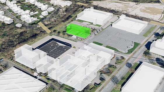
Digital tool for building analysis
Timo Klouth (Team Leader Architects) and Daniel Schaefer (Head of Product Management Composite) explain the functions and benefits of the state-of-the-art tool used by Ecclesia's teams of experts to accurately determine the value of buildings and assess risks. By entering the address, using a 3D building model and equipment features of the building in question, its value can be determined digitally. This saves time, increases the accuracy of the valuation and is an important resilience factor for sustainably hedging risks.
‘The platform uses the same valuations for features and special items that are also used by the team of architects in analogue valuations. This means that different standard buildings such as retirement homes, childcare centres and office and administration buildings can be valued simply and accurately,’ explains Daniel Schaefer. ‘The abbreviation GIS stands for Geoinformation System. One of four applications calculates the building insurance sum. This allows us to offer key accounts better digitalisation, which can be further improved in the future.’
Determine building values accurately
One of the main aspects of the platform is determining the value of buildings. The Ecclesia Group's GIS project was developed and made possible in collaboration with the Münster-based IT service provider con terra. ‘In the past, only the team of architects determined the building insurance sums. Since August 2021, the new system has enabled us to have various standard buildings - such as retirement homes, day-care centres, office and administration buildings - assessed by the departments themselves in a simplified manner and still achieve accurate results. For complex buildings, the team of architects is still available for the assessment. Our customers and we benefit from this together,’ explains Timo Klouth. ‘As thousands of buildings belong to the companies and institutions in our large customer base and we realise the appropriate insurance cover for our customers on the insurance market, the usual determination of the corresponding values by our teams would not be feasible. This absolutely time-consuming task could never be completed in a lifetime,’ emphasises Timo Klouth. ‘Precision is the decisive advantage. The previous use of alternative systems showed us that they were not able to determine the building values as correctly and precisely as we needed in order to fulfil our quality requirements. It was therefore of fundamental importance to have our own system developed by professionals, whose approach corresponds exactly to the professional approach of architects. With con terra, we have succeeded in building a perfect platform and actively participating in it.’
GIS platform (geographic information system)
Digital building valuation: Fully digital determination of the insurance value of a building, significantly reducing manual errors and speeding up the valuation process.
3D building model: Enables a precise and clear representation of the building and its cubature. This increases the accuracy of the assessment.
Integration of architects' knowledge: The GIS platform integrates the valuations for equipment features and special items that are also used by architects in analog valuations. Digital valuation is qualified and reliable.
Versatility: A wide range of standard buildings, from retirement homes and day care centers to office and administration buildings, can be valued in a targeted manner. The accuracy of the insurance values is significantly better compared to other programs.
App simplifies risk assessment
Another important module of the platform is risk assessment. "Markets are becoming more and more complex and it is increasingly difficult to place risks, especially without detailed risk information. Our risk assessment app enables our customers to answer the crucial questions about their buildings and thus obtain Ecclesia's own risk assessment," says Timo Klouth. "The insurers have made it clear to us in intensive discussions that more and more risk information is needed for the detailed contract modalities. Accordingly, we have also integrated a questionnaire into our app as a service for easy completion."
The questions within the app are not only used for risk assessment, but also to raise customer awareness. Questions about prevention systems can lead to targeted discussions and thus improve risk quality. The risk information is summarized in an ABC cluster, which enables an appealing and structured presentation of the portfolio and individual risks. The Dataroom for the fully digital tender presentation provides a central and secure environment for the management and exchange of site-specific tender documents. It improves transparency, traceability and communication between the parties involved, thereby promoting efficiency and modernity in the work processes.
Interfaces for site risks and extreme weather events
The GIS platform also integrates various external data sources to enable a comprehensive assessment. "We have a direct interface to Swiss Re to find out about potential location-related natural hazards such as river flooding, hailstorms, etc. for our customers. There is also a direct link to GeoVeris, a portal for geo and weather data. Here we can also quickly and easily query the usual flood and heavy rain hazard class data from the
insurance market. This integration allows us to access standard insurance data quickly and efficiently," explains Timo Klouth.
Practical application and customer benefits
The platform is designed to be easy to use and can be used by customer advisors to quickly and efficiently determine building values. "With the GIS platform, we enable our customer advisors to quickly determine building insurance sums without always having to send an architect from our team out," explains Timo Klouth.
Future developments
The successful system is being continuously developed. "Last year, for example, we were able to gain a lot of experience with the risk assessment application.
There will be further improvements in the future," emphasizes Timo Klouth. The Ecclesia Group's GIS platform represents a significant step forward in the digital determination of building insurance sums and risk assessment. It offers a precise, efficient and user-friendly solution that benefits both customers and insurers.
